- 93 Lavrio Avenue, Glyka Nera 153 54
- [email protected]

FUTURAL Open Call Smart Solution | EW4Fthiotida
Early Warning and Operational Coordination for Resilient Rural Communities
opsis CivilOps / EW4Fthiotida brings together smart sensors, AI-supported risk detection, mobile incident reports and operational coordination in one Common Operational Picture.
The solution helps authorities and rural communities prepare for and respond to forest fires, floods, heavy snowfall and other climate-related hazards.
Developed through the FUTURAL Open Call with funding from the European Union's Horizon Europe research and innovation programme.
Developed within the FUTURAL Open Call


This sub-project has received funding from the project FUTURAL (Grant Agreement number: 101083958) through its Open Call, funded by the European Union’s Horizon Europe research and innovation programme.
What is EW4Fthiotida?
EW4Fthiotida - Early Warning Solutions for Forest Fires, Floods and Snowfalls in Fthiotida - is a smart digital solution developed and validated in the Regional Unit of Fthiotida within the European FUTURAL project.
It combines the opsis CivilOps operational platform, AI-assisted surveillance cameras, IoT field sensors and a mobile reporting application. Data and alerts from these different sources are brought together in a central digital environment, helping Civil Protection authorities and technical services detect risks earlier, verify incidents and coordinate their response using reliable, real-time information.
Project facts
Solution
opsis CivilOps
Sub-project
EW4Fthiotida
Target area
Regional Unit of Fthiotida, Central Greece
FUTURAL domain
Resilience to Shocks
Main hazards
Forest fires, floods and heavy snowfall
One Solution. Connected Components.
CivilOps Operational Platform
A central web-based environment that consolidates incidents, alerts, resources, critical infrastructure and geospatial information into one Common Operational Picture.
Mobile Incident Reporting & Alerts
A mobile application that enables authorised community users and local stakeholders to submit geo-located incident reports with photographs and receive official risk notifications and protection instructions.
AI-Assisted Fire Detection
High-resolution cameras and AI algorithms support the continuous monitoring of rural and forest areas, identifying signs of smoke or fire and generating alerts for the Operations Center.
Water-Level Monitoring & Flood Warning
Field sensors and data analytics provide real-time information about river conditions and help identify potentially dangerous rising trends before flooding occurs.
Snow-Depth & Road-Condition Monitoring
Snow-depth sensors and live field data support the monitoring of mountainous road networks, helping authorities plan faster and more targeted winter-response actions.
From Detection to Coordinated Response
01
Detect
Monitor risks in real time using smart sensors, mobile app risk alerts and data analytics.
02
Decide
Access a clearer Common Operational Picture to support faster and better-informed decisions.
03
Respond
Coordinate resources, authorities and field stakeholders for a timely and effective response.
04
Protect
Safeguard people, infrastructure and the environment while strengthening the resilience of rural communities.
Functional Profile
opsis CivilOps / EW4Fthiotida is an integrated digital early-warning and incident-management solution developed to strengthen the resilience of rural communities in Fthiotida against forest fires, floods and heavy snowfall.
It combines a web-based operational coordination platform, a mobile reporting and alert application, IoT field sensors, surveillance cameras and AI-supported analytics. Data and alerts from these sources are consolidated into a real-time Common Operational Picture, enabling Civil Protection authorities and technical services to monitor risks, verify incidents, coordinate resources, communicate with field stakeholders and maintain a traceable history of actions.
Selected community representatives and volunteer organisations can use the mobile app to submit geo-located incident reports with photographs and receive official risk notifications. The solution supports earlier detection, faster decision-making, coordinated response and improved protection of people, infrastructure, agricultural activity and the natural environment.
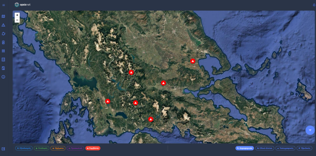
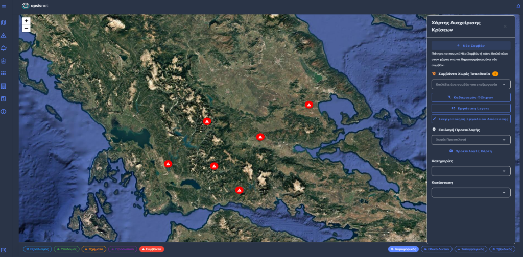
Core Capabilities
Within EW4Fthiotida, opsis CivilOps is used for:
- Providing a real-time Common Operational Picture through an interactive operational map.
- Consolidating alerts and data from AI-enabled cameras, IoT sensors and mobile incident reports.
- Supporting AI-assisted smoke and flame detection and the delivery of automatic alerts.
- Monitoring river water levels and identifying potentially dangerous rising trends.
- Monitoring snow depth and road-network conditions in mountainous areas.
- Enabling selected users to submit structured, geo-located incident reports with photographs.
- Delivering official risk notifications and safety guidance to community stakeholders.
- Supporting incident verification, resource coordination and communication with responsible authorities.
- Maintaining a digital history of incidents, communications and operational actions.
- Providing geospatial and critical-infrastructure layers to support faster, better-informed decisions.
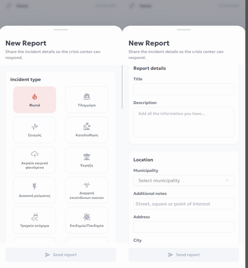
Mobile Reporting and Community Alerts
Technical monitoring equipment cannot cover every village, road or remote rural area. The mobile application complements cameras and field sensors by enabling selected community representatives, volunteer organisations and other authorised stakeholders to contribute structured information directly from the field.
Users can submit a report with:
- Incident type and description
- Accurate map location
- Geographical coordinates
- Contact information
- Photographs from the field
The same application allows users to receive official notifications, risk information and practical protection instructions from the responsible authority.
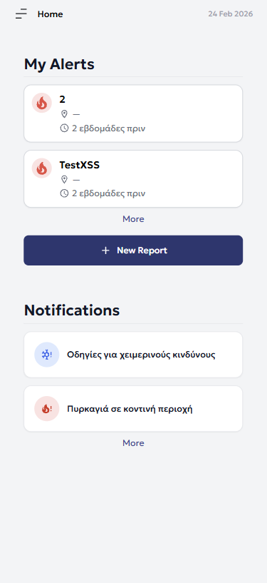
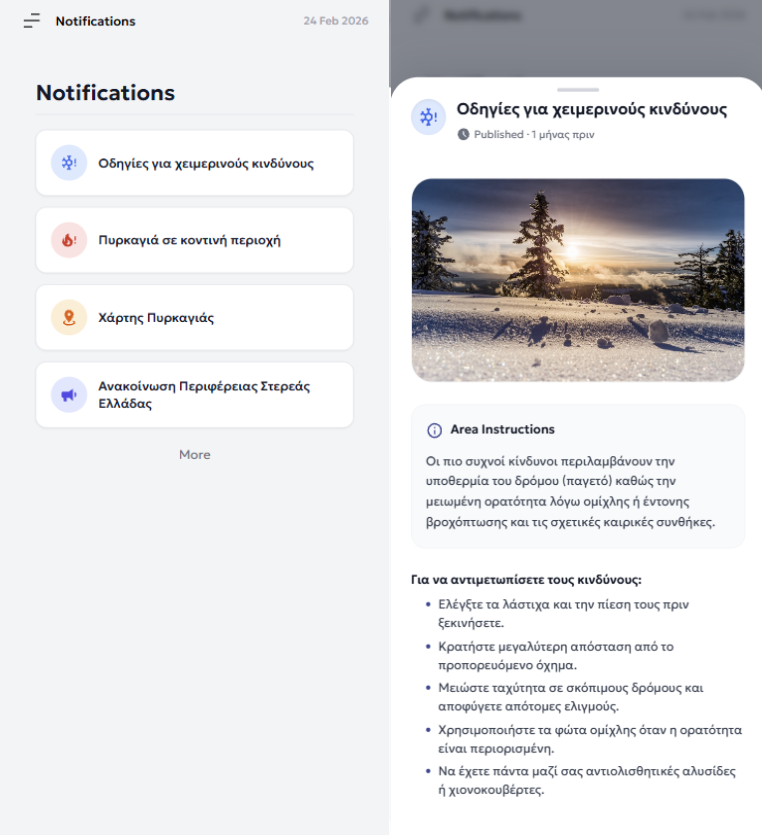
Notifications
Authorities can publish risk information and practical protection instructions for local stakeholders directly to the mobile application.
Who the Solution Supports
opsis CivilOps / EW4Fthiotida supports:
Civil Protection authorities and Operations Center personnel
Regional and municipal technical services
Emergency response services and field teams
Community representatives and volunteer organisations
Decision-makers responsible for preparedness, resource allocation and critical-infrastructure protection
Benefits for the Region and Local Communities
Faster Response
Helps reduce the time required to identify, verify and respond to climate-related incidents.
Better Coordination
Improves communication and operational coordination between authorities, services and field stakeholders.
Improved Situational Awareness
Brings information from sensors, cameras, mobile reports and operational resources into one unified environment.
Infrastructure Protection
Supports the monitoring of critical infrastructure that may be affected by extreme weather events.
Community Participation
Enables authorised local stakeholders to contribute structured, location-based information directly from the field.
Scalable Deployment
The solution can be adapted and deployed in other rural and regional areas across Greece and Europe.
Watch the Solution
About FUTURAL
FUTURAL is a European project that develops and deploys innovative Smart Solutions to strengthen the resilience, sustainability and quality of life of rural communities across Europe.
EW4Fthiotida – Early Warning Solutions for Forest Fires, Floods and Snowfalls in Fthiotida – was selected and funded through the FUTURAL Open Call. The sub-project brings together MOBICS S.A., the Region of Central Greece and OPSISNET S.A. to develop, deploy and validate an integrated early-warning and operational-coordination solution in the Regional Unit of Fthiotida.
This sub-project has received funding from the project FUTURAL (Grant Agreement number: 101083958) through its Open Call, funded by the European Union's Horizon Europe research and innovation programme.
Download the EW4Fthiotida e-brochure
Explore the solution, its architecture, core components, use cases and expected benefits.
Interested in opsis CivilOps?
Contact us to learn more about the platform and its use in civil protection, operational readiness and rural resilience.
Funding visibility

Sub-project consortium



Funded by the European Union. Views and opinions expressed are however those of the author(s) only and do not necessarily reflect those of the European Union or the European Research Executive Agency (REA). Neither the European Union nor the granting authority can be held responsible for them.